
The word virga is derived from Latin meaning “twig” or “branch”.
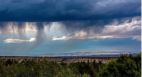
Ever looked up and seen those wispy, tail-like streaks hanging from a cloud that never quite reach the ground? That’s a fascinating phenomenon called virga.
It’s essentially “ghost rain”—precipitation that starts falling but vanishes before it can hit your umbrella. Here is a quick breakdown of how it works and why it actually changes the weather around it:
Why does it happen?
The main culprit is low humidity. When raindrops fall into a layer of very dry air, that air acts like a giant sponge. It “soaks up” the moisture through evaporation, turning the liquid drops back into water vapour mid-air.
The “Cooling” Effect
As that rain evaporates, it absorbs heat from the surrounding atmosphere. This makes the air much colder and heavier.
The Downward Push: This chilled, heavy air starts to sink rapidly.
Cloud Growth Stops: These sinking air currents (downdrafts) actually push back against the rising warm air that fuels a cumulonimbus cloud.
The Result: By creating these downdrafts, the virga essentially “chokes” the storm cloud, preventing it from growing any larger.
You often see virga over a desert, where low humidity and high temperatures can cause rain to evaporate shortly after being released by clouds. Or you might see virga at high altitudes; in fact, the precipitation often starts out in the form of ice crystals. Virga is commonly seen in the U.S. West and above the Canadian Prairies, in the Middle East, Australia and North Africa.  At some northerly latitudes, virga sometimes paints the sky above. It’s an especially dramatic sight at sunrise or sunset.
Source: EarthSky


